Sunday, December 6, 2015

Looking to Peru from the air

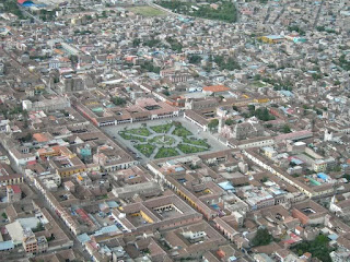
Some aerial views of Peru

Perhaps soon will be pictures shots from the Peruvian TV Chasqui II, developed at the National University of Engineering, UNI.


The map of Peru from space. Humboldt sea, coast, mountains and jungle are appreciated. Lake Titicaca is always visible on any scale map of Peru. Amazing.


First, some views of the capital of Peru, Lima, a privileged city for being at sea. 


Miraflores, one of the districts to the sea. Great pictures.


Callao, Peru's first port coupled to the capital, Lima. Foul development and their capacity is limited by lack of political and firmness in decision authorities. La Punta, the gateway to the Italian immigrants who then brought their culture and ingenuity in Peru. Real Felipe Fortress, last stronghold of the Spanish before withdraw forever from Peru, a colony which had been plundered for 300 years is appreciated.


North, Caral is the third oldest in the world, contemporary with the pyramids of Egypt place, is located in the middle of mountains 190 km north of Lima. It is the oldest civilization in America and has approximately 5,000 years old.


South of Lima, Ica we find the Nazca Lines, preserved thanks to the selfless work of Dona Maria Reiche, a German I love Peru with intensity.


Huacahina lagoon, unique oasis in America.

Arequipa, rebellious and untamed city, called the White City building material, ashlar used profusely in the historic capital.


Chachani volcano 55 kilometers, 32 kilometers Pichu Pichu and the imposing Misti just 17.5 kilometers from the main square. There are more volcanoes, but these are the closest.


Cotahuasi Canyon, Arequipa, the fourth deepest in the world with a depth of 3.535 meters cannon; It is second only to Yarlung Tsangpo Canyon with 5.590 meters, Apurimac Canyon with 4.691 meters, Kali Gandaki Canyon with 4,375 deep.


Ayacucho, the city where the independence of Peru was consolidated. A magnificent aerial photography. The Cathedral and the Municipality is observed. It is a city that has 33 colonial churches, but it is a pity that not all are in good condition. But worth seeing and appreciating the original form of construction of altarpieces in the Cathedral. I do not know if these altarpieces, which seem to overcome gravity, but there's nothing like seeing them up close are made elsewhere in the world. And be amazed.


Cusco, the capital of the Incas always mysterious, always magical. The imposing colonial church is observed.


Machu Pichu, from land or from the air is always interesting.


Puno, the highest lake in the world. It is navigable and belongs to two countries, Peru and Bolivia.


In Lambayeque, birthplace of important pre-Hispanic cultures, the Museum of Sipan can be seen, with an architecture that resembles a pre-Inca pyramid that houses important treasures of the Moche culture. There are more than 2000 pieces of gold, besides pottery and funerary objects. If there is as much by the depredations of tomb robbers who for decades almost wiped out the vestiges.


Los Andes in the Cordillera Blanca show the imposing mountains and beautiful lakes. Pity that the warming has setback in glaciers and loss of water masses.


The forest always beautiful, always mysterious.


The quarter note. In the south, the Madre de Dios there is something to show for now but with the depredations of illegal miners and protected in collusion with the authorities, indolent, is running out with every trace of beauty. What happened in Brazil Bento Rodriguez, is repeated with more force in Peru.


Small towns also have their charm. San Miguel, Cajamarca, in northern Peru, where I was born. The photographs were taken with a drone.


To appreciate all this must come to Peru. Some scenes  of the landing at the Jorge Chavez International Airport, located in the capital.

https://www.youtube.com/watch?v=jqqCF0PhTNM


Mirando al Perú desde el aire

Algunas vistas  aéreas del Perú

Quizás pronto sean fotos tomas desde el satélite peruano Chasqui II, desarrollado en la Universidad Nacional de Ingeniería, UNI.


El mapa del Perú desde el espacio. Se aprecian el mar de Humboldt,  la costa, sierra y selva. El lago Titicaca siempre es visible en cualquier escala del mapa del Perú. Impresionante.


En primer lugar,  algunas vistas de la capital del Perú, Lima, una ciudad privilegiada por estar a orilla del mar. 


Miraflores, uno de los distritos a orillas del mar. Estupendas fotografías


Callao, el  primer puerto del Perú unido a la  capital, Lima. Falta desarrollo y su capacidad es limitada por falta de decisión política y firmeza en las autoridades. La punta, la puerta de entrada de los  inmigrantes italianos que luego aportaron su  cultura e ingenio al Perú. Se aprecia la Fortaleza del Real Felipe, último reducto de los española antes de retirase para siempre del Perú, una colonia a la que habían depredado durante 300 años.


Al Norte,  Caral es el tercer lugar más antiguo del mundo, contemporáneo con las pirámides de Egipto, está ubicada en medio de montañas a 190 Km al Norte de Lima. Es la civilización más antigua de América y posee una antigüedad aproximada de 5,000 años.


Al sur de Lima, en Ica podemos encontrar las Líneas de Nazca, que se conservan gracias al trabajo abnegado  de doña María Reiche, alemana que amo al Perú con intensidad.
La laguna de Huacahina,  único oasis en América.


Arequipa, la ciudad rebelde e indómita, llamada Ciudad Blanca por el material de construcción, el sillar empleado profusamente en la capital histórica.


El volcán Chachani  a 55 kilómetros, Pichu Pichu a  32 kilómetros y el imponente  Misti  a solo 17,5 kilómetros de la Plaza de armas. Hay más volcanes, pero éstos son los más cercanos.


El cañón de Cotahuasi, Arequipa, es el cuarto cañón más profundo del mundo con una profundidad de 3,535 metros; es sólo superado por el Cañón de Yarlung Tsangpo con 5,590 metros, Cañón de Apurímac con 4,691 metros, Cañón de Kali Gandaki con 4,375 de profundidad.


Ayacucho, la ciudad donde se consolidó la independencia del Perú. Una magnífica fotografía aérea. Se observa la Catedral y  la Municipalidad. Es una ciudad que tiene 33 iglesias coloniales, aunque es una pena que no todas están en buen estado. Pero vale la pena verlas y apreciar la original forma de construcción de  los retablos en la Catedral.  No sé si en otros lugares del mundo se hacen estos retablos, que parecen vencer  a la gravedad, pero no hay nada como verlos de cerca. Y quedar asombrado.


Cusco, la capital de los incas siempre misteriosa, siempre mágica. Se observa las imponentes iglesia coloniales.


Machu Pichu, desde tierra o desde el aire siempre es interesante.


Puno, el lago más alto del mundo. Es navegable y pertenece a dos países, Perú y Bolivia.


En Lambayeque, cuna de importantes culturas prehispánicas, se aprecia el Museo del Señor  de Sipán, con una arquitectura que se asemeja a una pirámide pre inca  y que alberga importantes  tesoros de la cultura Mochica.  Hay más de 2000 piezas de oro, además de cerámica y ajuares funerarios. Si no hay mayor cantidad es por la acción depredadora de saqueadores de tumbas que durante decenios  casi acabaron con los vestigios


Los Andes en la Cordillera Blanca muestran los imponentes nevados y las hermosas lagunas. Lástima que con el calentamiento haya retroceso en los glaciares y pérdida de masad de agua.


La selva siempre hermosa, siempre misteriosa.


La nota negra. En el sur, en Madre de Dios hay algo que mostrar por ahora pero con la acción depredadora de mineros ilegales, protegidos y en complicidad con las autoridades, indolentes, se va acabando con todo rastro de belleza. Lo que sucedió en Brasil Bento Rodríguez, se repite con más fuerza en el Perú.


Los pueblos pequeños también tienen su encanto. San Miguel , Cajamarca, al norte del Perú, lugar donde nací. Las fotografías fueron tomadas con un drone.  


Para apreciar todo esto debe llegar  al Perú. Algunas escenas del del aterrizaje en el Aeropuerto Internacional Jorge Chávez, ubicado en la capital.

https://www.youtube.com/watch?v=jqqCF0PhTNM